73
Main Menu
Points Tab
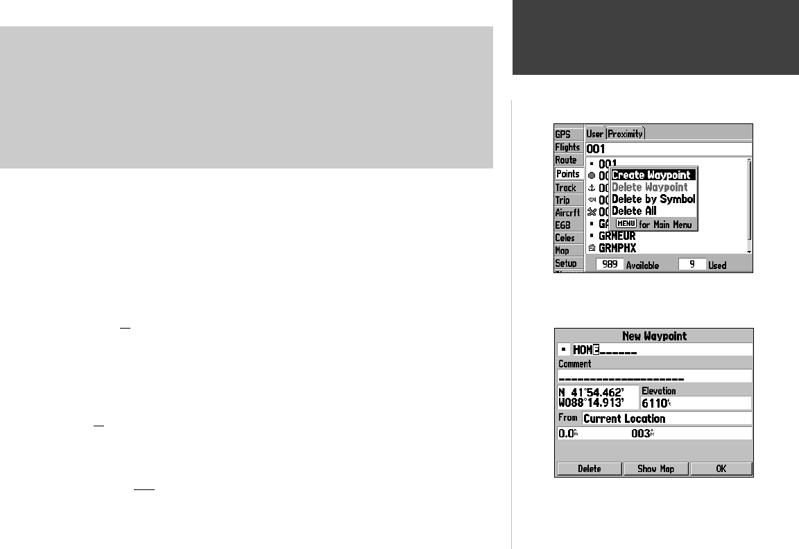
With the User waypoints screen displayed, press MENU to
display context-sensitive options for this screen. Use the ARROW
KEYPAD, then ENTER to select the desired option.
When creating a new waypoint, use the ARROW KEYPAD and
ENTER to input waypoint name and position.
The following options are available:
• Create Waypoint— allows you to create a new waypoint by entering the position coordinates
(latitude/longitude) or by referencing bearing/distance from another point. (Recall from page 48 that
the ENTER/MARK key can also be used to create a user waypoint at your present position.)
• Delete Waypoint— deletes the highlighted user waypoint from the list.
• Delete By Symbol— allows you to delete all user waypoints that have a common waypoint symbol.
The waypoint symbols are shown at the waypoint location on the map display.
• Delete All— deletes all saved user waypoints from memory.
To create a user waypoint by entering position coordinates or referencing another
point:
1. From the ‘Points’ tab, use the ARROW KEYPAD to select ‘User’ at the top of the page and press
MENU.
2. Use the ARROW KEYPAD to select ‘Create Waypoint’ and press ENTER. A New Waypoint Page will
appear with a pre-assigned name, symbol and present position for the new waypoint.
3. To change the waypoint name (or comment): highlight the name (comment) fi eld at the top of the
page and press ENTER. Use the ARROW KEYPAD to enter the desired waypoint name (com-
ment)—UP/DOWN to select the highlighted character and RIGHT to move to the next character fi eld.
Press ENTER once all characters for the waypoint name (comment) have been entered.
4. To select a different waypoint symbol which will appear on the map: Highlight the symbol fi eld (at
the top left corner of the page) and press ENTER. A list of available symbols will appear. Use the
ARROW KEYPAD to select the desired symbol and press ENTER.
5. To enter the waypoint position (or elevation): highlight the position (elevation) fi eld in the middle
of the page and press ENTER. Use the ARROW KEYPAD to enter the position coordinates. Press
ENTER once all characters for the position (elevation) have been entered.
6. To enter the waypoint position by referencing another point: highlight the ‘From’ fi eld and select ‘Cur-
rent Location’ or another location as the reference point. Next, highlight the distance fi eld and enter
the distance from the reference point to the new waypoint location. Finally, highlight the bearing fi eld
and enter the bearing from the reference point to the new waypoint location.
7. To save the new waypoint, highlight the on-screen GOTO button and press ENTER.
190-00283-00Backup.indd 73 12/8/2002, 8:09:32 PM


