70
Getting Started
Main Page Sequence
70
Reference
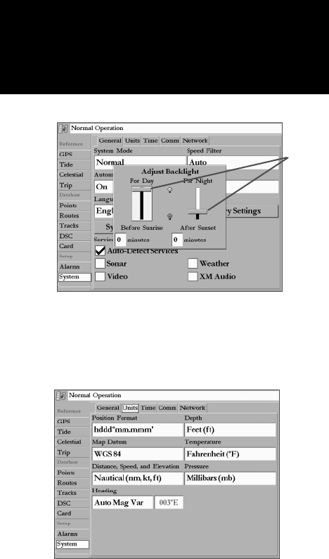
• Automatic Backlight – automatically adjusts the display brightness to a specifi ed level at sunrise and
sunset. Offset minutes for Before Sunrise and After Sunset may also be specifi ed.
To adjust the Automatic Backlight settings:
1. With “Automatic Backlight” set to ‘On’, select the ‘Setup’ button to the right.
2. To adjust the backlight levels For Day and For Night, highlight the desired slider and press ENTER.
3. Press UP or DOWN on the ARROW KEYPAD to increase/decrease the level and press ENTER.
4. To adjust the offset minutes, select the desired minutes fi eld and press ENTER.
5. Enter the desired offset for Before Sunrise or After Sunset. If left at zero, the unit automatically changes to
the specifi ed level at sunrise/sunset. Press QUIT to exit the Adjust Backlight window.
• Beeper – controls audible beep. Select from ‘Off’, ‘Alarms Only’ (sounds for alarms/messages), or
‘Key and Alarm’ (sounds for key presses and alarms/messages).
• Language – select from various languages for the unit’s on-screen display.
The following option buttons are available:
• Factory Settings – restores all settings to Garmin’s original setup values for the entire unit.
• System Information – displays the unit’s software, basemap version, and electronic serial number.
• Services - As you add optional hardware to the MFD or Garmin Marine Network, additional
Services choices may appear automatically. Once a new device has been detected on the Network,
unchecking the “Auto-Detect Services” option will speed up the power on sequence. If unchecked
and new hardware is added, you must manually check the box to enable the new device.
Units Submenu Tab— defi nes settings for Position Format, Depth, Map Datum, Temperature,
Distance, Speed, and Elevation, Pressure, and Heading.
The following settings are available:
• Position Format – is used to change the coordinate system in which a given position reading is dis-
played. You should only change the position format if you are using a map or chart that specifi es a
different position format or wish to use a format you are familiar with. The default format is latitude
and longitude in degrees, minutes, and thousandths of a minute (hddd°mm.mmm’).
Main Menu—System Tab
(Units Submenu)
Main Menu: System Tab
Automatic Backlight Adjustment
Sliders


