48
Main Pages
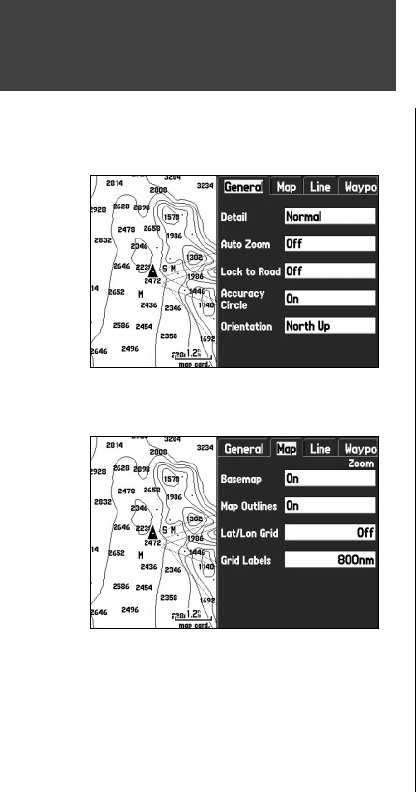
‘General’ tab
Detail – Most, More, Normal, Less, Least: controls how much map detail is displayed. This setting only
applies to any map feature set to ‘Auto’. Those features that have a specifi ed scale or that are turned ‘Off’
are unaffected by this setting.
AutoZoom – On/Off: when ‘On,’ the map automatically adjusts the map scale to a lower scale as you
approach your destination point.
Lock to Roads – On/Off: When ‘On,’ if the vehicle’s position is close enough to a road, the Map Page
displays the current position icon as “locked” to the road.
Accuracy Circle – On/Off: When ‘On,’ the circle represents the approximate accuracy of the unit based
on EPE, DOP, and basemap quality. Your current position is displayed within the circle.
Orientation – North Up: fi xes the top of the map display to a north heading. Track Up: fi xes the top of
the map display to the current track heading. Course Up: fi xes the map so the direction of navigation is
always “up” and turns the navigation leg line vertical on the screen.
‘ Map’ tab
Basemap – On/Off: turns the built in basemap on or off.
Map Outlines – On/Off: turns outlines of data card maps on or off.
Lat/Lon Grid – Off, Auto, 20 ft. to 800 nm/mi: sets the maximum scale at which the Lat/Lon grid ap-
pears on the screen. Some types of data are only displayed to certain zoom scales.
Grid Labels – Off, Auto, 20 ft. to 800 nm/mi: sets the maximum scale at which the grid labels appear on
the screen. Some types of data are only displayed to certain zoom scales.
Map Page
General Tab of Map Page Setup Menu
Map Tab of Map Page Setup Menu
190-00335-00_0A.indd 48 4/7/2004, 1:50:43 PM


